With geomatics, Renault Group maps the mobility of tomorrow
Article summary
Behind a charging station, a driving simulation or an industrial decision, there is often a map. Or rather, millions of spatial data points, analyzed, cross-referenced and interpreted. This is the realm of geomatics, a still little-known discipline that is already central at Renault Group. From the deployment of Fast Charge stations to the measurement of road noise, this is an immersion into a science that turns data into concrete decisions… and mobility into a field of innovation.
Key takeaways
Geomatics makes it possible to turn spatial (geolocated) data into concrete decisions.
It has been used at Renault Group for over 10 years.
It is applied in key areas such as electric mobility, engineering, marketing and simulation.
Concrete projects include Fast Charge, geomarketing, APACHE, driving simulation and the Road Slopes Calculator.
A strategic lever for smarter, more sustainable and connected mobility.
Looking beyond the mapping of charging stations
Imagine a map. Not the kind you check when heading off for the weekend. A living, evolving map, constantly fed by data from satellites, sensors, vehicles and even human behavior
A map that doesn’t just show roads, but also uses, flows and opportunities.
That’s what geomatics makes possible.
« Geomatics is a combination of geography and computer science. It is a discipline that makes it possible to collect, process and analyze geolocated data in order to represent reality. »
In other words: turning the real world into a digital twin. Every point becomes a piece of information. Every journey tells a story. Every data point helps inform decisions.
At Renault Group, geomatics is a strategic tool that has been used for more than ten years to address very concrete challenges: where to install an electric vehicle charging station, how to adapt a vehicle to a specific country and how to enhance the customer experience.
Its strength lies in its ability to bring together different fields: data science, engineering, marketing and artificial intelligence, while producing clear, actionable outputs such as maps, dashboards and simulations.
How geomatics is reshaping five key projects
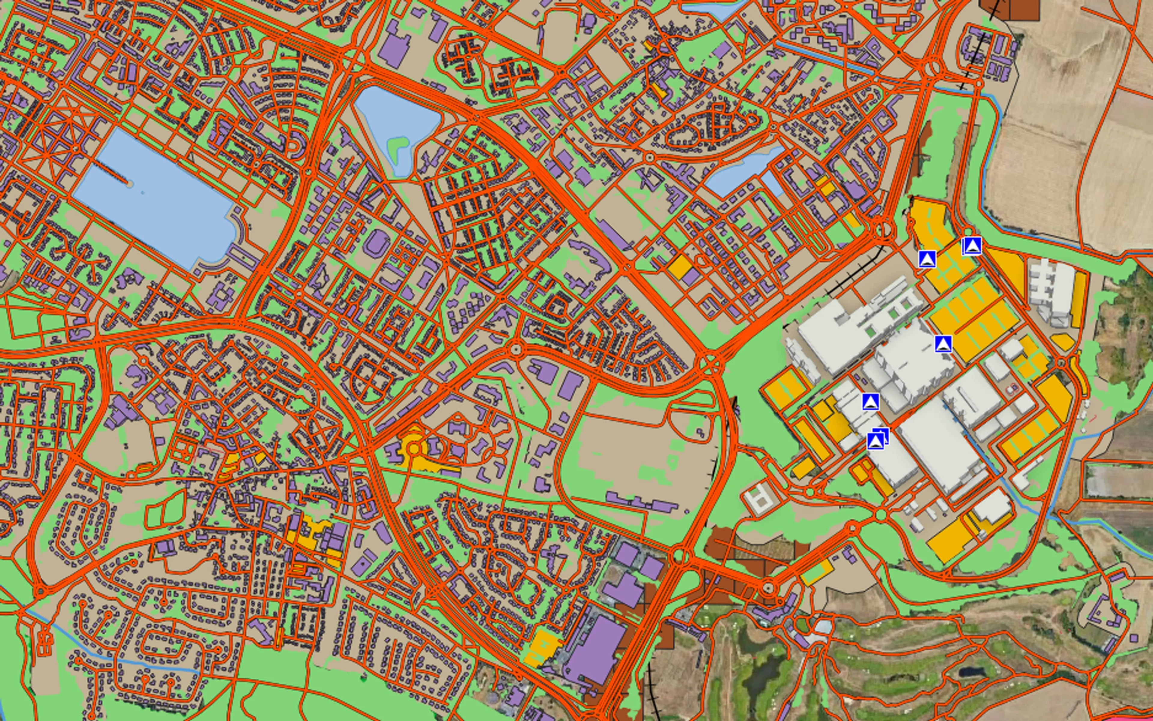
Fast Charge: choosing the right location, at the right time
Where should a fast-charging station be installed? Behind this seemingly simple question lies a complex equation that geomatics helps solve by combining multiple data sources: road traffic, population density, competition and even mobility patterns.
In 2024, more than 5,500 sites were analyzed across four countries, including nearly 2,700 potential locations identified in the United Kingdom. But the real feat comes next: once the stations are installed, teams analyze their usage in real time. Traffic, user profiles, competition… everything is modeled. ‘We’ve developed a digital twin that we continuously maintain, because a competing charging station can change the entire ecosystem overnight,’ explains Ludovic Picot.
The result: faster, more reliable decisions and significant savings during the study phases.
Geomarketing: understanding territories to sell better
Geomatics also extends into business through geomarketing. It makes it possible to analyze catchment areas, home-to-work flows, socio-demographic data and dealership performance in order to understand why a sales point performs… or doesn’t.
A concrete example: when a dealership underperforms, teams can visualize customer flows on a map and detect ‘cannibalization’ effects between dealerships.
Geomarketing thus enables precise, data-driven decisions on the location of new sites, commercial segmentation and local marketing actions. Today, more than 1,000 users leverage these tools internally.
APACHE Project: when the car becomes a noise sensor
What if your car could measure road noise? That’s the ambition behind the APACHE project. Thanks to onboard sensors, vehicles collect data on vibrations, road surface quality and rolling noise. This data is then transformed into maps that can be used by local authorities. Why? Because road noise accounts for €81 billion out of the €146 billion social cost of noise in France. And above all, because the main source of noise today is no longer the engine, it’s the road.
Thanks to geomatics, Renault Group can:
map the noisiest areas,
identify which roads should be prioritized for renovation,
improve the accuracy of acoustic models.
An innovation awarded a 2024 Golden Decibel, paving the way for new services for local communities.s.
Driving simulation: designing vehicles before they even hit the road
Geomatics-based simulation also makes it possible to test a vehicle that doesn’t yet exist. Using route identification tools and driving simulations, teams can generate realistic routes anywhere in the world, simulate driving behaviors and create consistent speed profiles. For Alpine projects, more than 1,100 routes have been simulated across the United States, Europe and the Middle East.
The result: better-sized vehicles, reduced testing phases and savings estimated in the hundreds of thousands of euros. Here, geomatics becomes a true accelerator of development.
Road Slopes Calculator: understanding roads around the world
Not all roads are created equal, and above all they don’t all have the same gradient. The Road Slopes Calculator makes it possible to map slope distribution at the scale of an entire country, helping to better adapt vehicles to local conditions.
By combining open-source tools (road networks, elevation data, etc.) with proprietary algorithms, Renault Group can generate slope histograms and detailed analyses by road type.
This tool is set to be deployed across the Group’s main markets, more than 25 countries, from France to Brazil and India.
A science at the heart of tomorrow’s mobility
What emerges from all these projects is a simple idea: data alone is not enough. What truly matters is what we do with it. Geomatics enables this crucial shift from raw data to decision-making, in other words, from analysis to value.
And what about tomorrow? With the rise of artificial intelligence, connected vehicles and digital twins, geomatics could become one of the invisible pillars of mobility. A discreet yet essential discipline, like a map we don’t always look at… but that guides every journey
FAQ
01
What is geomatics?
02
What is geomatics used for at Renault Group?
03
Why is geomatics strategic for mobility?
Geomatics is a discipline that combines geography and computer science to collect, analyze and leverage geolocated data. It makes it possible to represent the real world through intelligent maps and digital models.
At Renault Group, geomatics is used across a wide range of projects: the deployment of charging stations, analysis of commercial performance, driving simulation and the assessment of road quality. It helps enable faster and more accurate decision-making.
In the field of mobility, geomatics is strategic because it helps understand real driver behaviors, adapt vehicles to different environments and optimize infrastructure. It plays a key role in developing smarter, more sustainable and better-connected mobility.